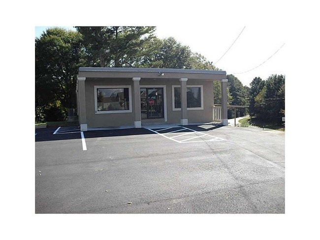
Property Record
3043 Braselton Hwy, Dacula, GA 30019

NEARBY LISTINGS FOR SALE OR LEASE
Property Detail
3043 Braselton Hwy
3-002-081
Hwy 124
Officebuilding
STATE HWY 124
X
Gwinnett
13135C0036F
Georgia
2025
0.63 AC
2025
Suwanee/Buford
050621
Atlanta
4,032 SF
Atlanta-Sandy Springs-Roswell, GA
DEMOGRAPHICS near 3043 Braselton Hwy
1 Mile
3 Mile
5 Mile
2024 Total Population
6,765
59,763
141,351
2029 Population
7,097
62,917
149,666
Pop Growth 2024-2029
+ 4.91%
+ 5.28%
+ 5.88%
Average Age
40
38
38
2024 Total Households
2,212
18,705
44,997
HH Growth 2024-2029
+ 4.97%
+ 5.46%
+ 6.04%
Median Household Inc
$104,767
$103,817
$98,712
Avg Household Size
3.00
3.10
3.10
2024 Avg HH Vehicles
2.00
2.00
2.00
Median Home Value
$329,535
$344,483
$334,881
Median Year Built
2000
2003
2003
Nearby Places
Map Layers
Map Styles
 Street
 Aerial
- Restaurants
- Banks
- Shops
- Fitness
- Groceries
PUBLIC TRANSPORTATION
AIRPORT
Hartsfield - Jackson Atlanta International
DRIVE
WALK
Distance
Hartsfield - Jackson Atlanta International
61 min
48.8 mi
SALE & LEASE HISTORY
LISTING DATE
SALE/LEASE

Sep 24, 2016
For Sale
Nov 03, 2016
For Sale
Mar 20, 2024
For Sale
Nearby Properties
Address
Land Use
TOTAL SIZE
Lot Size
Zoning
Address
Land Use
TOTAL SIZE
Lot Size
Zoning
473,883 SF
85.71 AC
RA200
Address
Land Use
TOTAL SIZE
Lot Size
Zoning
1,113,809 SF
57.50 AC
M1
Address
Land Use
TOTAL SIZE
Lot Size
Zoning
403,129 SF
126.91 AC
RA200
Address
Land Use
TOTAL SIZE
Lot Size
Zoning
394,831 SF
16.37 AC
RM24
Address
Land Use
TOTAL SIZE
Lot Size
Zoning
684,003 SF
60.84 AC
M1
Address
Land Use
TOTAL SIZE
Lot Size
Zoning
372,813 SF
172.70 AC
RA200
Address
Land Use
TOTAL SIZE
Lot Size
Zoning
404,091 SF
58.20 AC
RA200
Address
Land Use
TOTAL SIZE
Lot Size
Zoning
619,498 SF
51.81 AC
M1
Address
Land Use
TOTAL SIZE
Lot Size
Zoning
335,641 SF
28.90 AC
RM10
Address
Land Use
TOTAL SIZE
Lot Size
Zoning
348,358 SF
7.80 AC
H7
Address
Land Use
TOTAL SIZE
Lot Size
Zoning
335,438 SF
10.94 AC
MUR
Address
Land Use
TOTAL SIZE
Lot Size
Zoning
121,100 SF
3.74 AC
RM24
Address
Land Use
TOTAL SIZE
Lot Size
Zoning
192,805 SF
12.40 AC
RM24
Address
Land Use
TOTAL SIZE
Lot Size
Zoning
280,168 SF
29.08 AC
M1
Address
Land Use
TOTAL SIZE
Lot Size
Zoning
233,266 SF
17.39 AC
RA200
Address
Land Use
TOTAL SIZE
Lot Size
Zoning
352,952 SF
16.97 AC
RM10
Address
Land Use
TOTAL SIZE
Lot Size
Zoning
158,307 SF
26.77 AC
R75
Address
Land Use
TOTAL SIZE
Lot Size
Zoning
162,013 SF
20.23 AC
RA200
Address
Land Use
TOTAL SIZE
Lot Size
Zoning
138,229 SF
7.97 AC
OI
Address
Land Use
TOTAL SIZE
Lot Size
Zoning
23,126 SF
88.56 AC
RA200
Address
Land Use
TOTAL SIZE
Lot Size
Zoning
124,425 SF
20.73 AC
RA200
Address
Land Use
TOTAL SIZE
Lot Size
Zoning
329,765 SF
33.06 AC
C2
Address
Land Use
TOTAL SIZE
Lot Size
Zoning
131,160 SF
17.89 AC
RA200
Address
Land Use
TOTAL SIZE
Lot Size
Zoning
110,356 SF
20.42 AC
RA200
Address
Land Use
TOTAL SIZE
Lot Size
Zoning
97,824 SF
13.71 AC
M1
Address
Land Use
TOTAL SIZE
Lot Size
Zoning
93,702 SF
5.66 AC
C2
Address
Land Use
TOTAL SIZE
Lot Size
Zoning
256,065 SF
34.36 AC
M1
Address
Land Use
TOTAL SIZE
Lot Size
Zoning
116,332 SF
4.83 AC
OI
Address
Land Use
TOTAL SIZE
Lot Size
Zoning
84,890 SF
20.02 AC
RA200
Address
Land Use
TOTAL SIZE
Lot Size
Zoning
41,757 SF
19.66 AC
RA200
The World's #1 Commercial Real Estate Marketplace
Connect with us
© 2025 CoStar Group
The information above has been obtained from sources believed reliable. While we do not doubt its accuracy we have not verified it and make no guarantee, warranty or representation about it. It is your responsibility to independently confirm its accuracy and completeness. Any projections, opinions, assumptions, or estimates used are for example only and do not represent the current or future performance of the property. The value of this transaction to you depends on tax and other factors which should be evaluated by your tax, financial, and legal advisors. You and your advisors should conduct a careful, independent investigation of the property to determine to your satisfaction the suitability of the property for your needs.